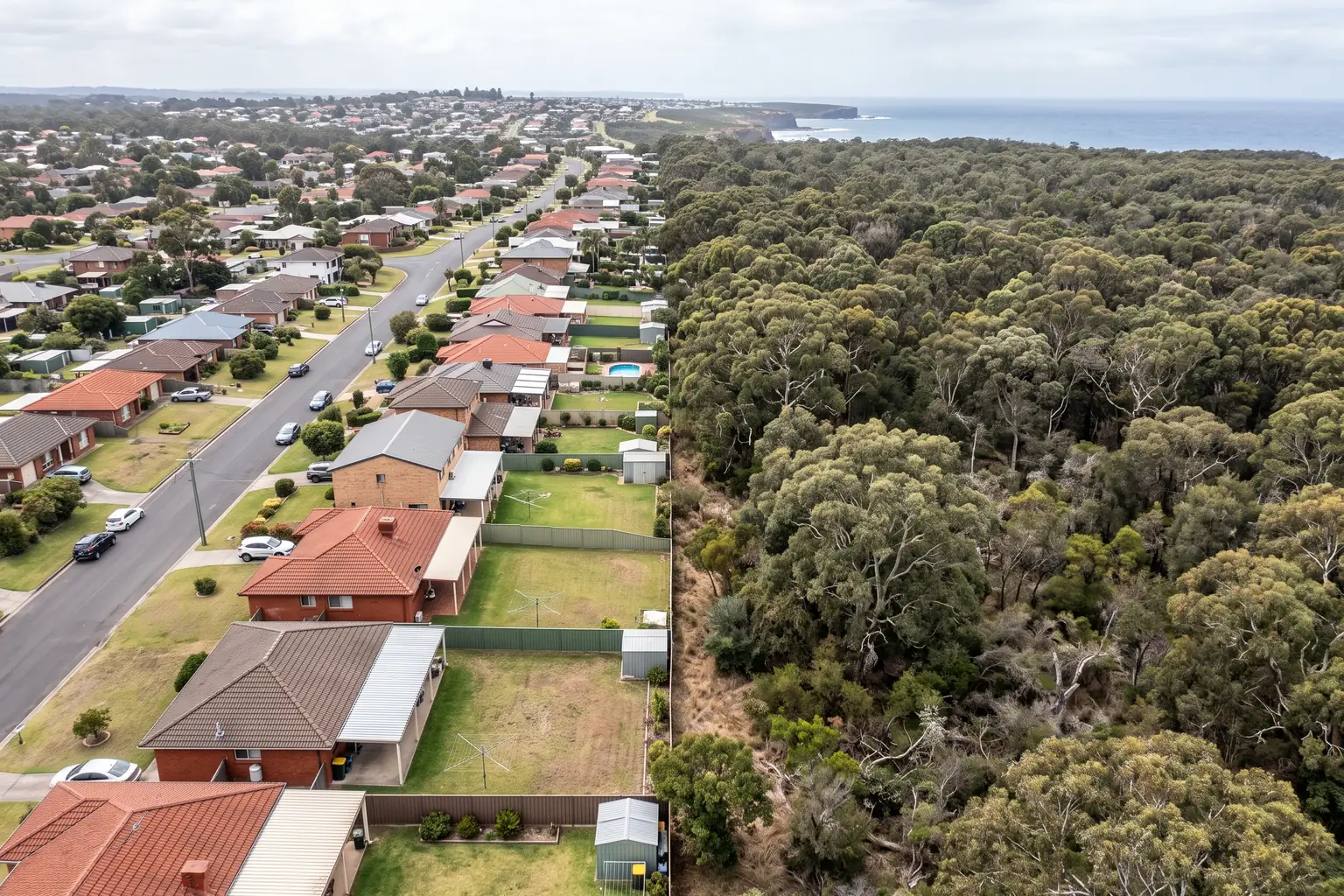
Two blocks on the same street can both sit inside the bush fire prone land map and carry wildly different projects. The map is a switch that turns a process on. The BAL rating is the number that decides what the process costs you, how much of your land you have to give up, and on a subdivision, whether the Rural Fire Service gets a veto nobody warned you about.
The call I remember most on this topic came from a bloke who had already spent about eleven thousand dollars.
Two-lot Torrens subdivision on the edge of a coastal town, rear third of the block backing onto a reserve. Survey done, plans drawn, a stormwater concept, the lot layout he'd been imagining for six years. He rang because his planner had just told him the application would need a bush fire safety authority from the Rural Fire Service, and he wanted to know whether that was a form or a problem.
It was a problem. Not a fatal one, as it turned out, but the answer took four months and cost him the rear lot's back garden.
What got him was not that his land was mapped. He knew it was mapped. It had said so on the planning certificate when he bought the place in 2019, and he'd read that line and thought, reasonably enough, that it meant he'd need the shutters and the mesh screens if he ever built. Everyone knows that bit. What he did not know was that on a subdivision the mapping does something else entirely, and that the body making the call would not be his council.
I spent long enough on the assessment side to have watched this from the other desk, and I'd say bush fire is the constraint owners most consistently misjudge in both directions. Half of them panic about a mapping status that will cost them a few thousand in window glazing. The other half wave off a rear boundary that is about to eat a fifth of their site.
Two words that do two different jobs
The confusion is baked into the language, so let's separate the terms before anything else.
Bush fire prone land is a mapping status. Under section 10.3 of the Environmental Planning and Assessment Act 1979, councils prepare a bush fire prone land map for their area and the Commissioner of the NSW Rural Fire Service certifies it. Your land either falls inside a mapped category or it doesn't. There's no severity in it and no scale. It's a switch, and the switch turns on an assessment process. You'll find it on your 10.7 planning certificate, and the RFS publishes an online tool so you can check any address in a minute.
BAL is a Bushfire Attack Level, and it is a measured result rather than a status. A consultant assesses your specific building envelope against Australian Standard AS 3959, Construction of buildings in bush fire prone areas, using the vegetation around you, the slope beneath it, and the distance between that vegetation and where you propose to put a wall. The output is one of six categories. That number, not the map, is what your builder prices.
Notice the spelling while you're here, because it tells you which register somebody is writing in. The Act and the RFS say "bush fire" as two words. The standard and the acronym say "bushfire". A report that mixes them isn't wrong, but a consultant who uses the statutory spelling in the statutory places has usually read the statutory documents.
The six categories, and what they actually mean
The RFS describes them plainly, and I'd rather quote than paraphrase:
- BAL–LOW — lowest risk from a potential fire.
- BAL–12.5 — risk is primarily from potential embers during a fire.
- BAL–19 — moderate risk, particularly from embers and burning debris.
- BAL–29 — high risk, particularly from embers, debris and heat.
- BAL–40 — very high risk. Likely to be impacted by embers, debris, heat and potentially flames.
- BAL–FZ — extreme risk. Directly exposed to the flames of a potential fire front.
Each step up buys you more construction requirements: glazing, screening, seals, decking, subfloor treatment, the lot. I won't publish dollar figures for the jump between one level and the next, because I've seen the same rating priced at wildly different numbers by different builders in the same year and I have no defensible source for a range. What I will say is that the gap between BAL–12.5 and BAL–29 is the sort of number that shows up in a feasibility as a line item you notice, and the gap between BAL–29 and BAL–FZ is the sort that changes what you build or whether you build.
Which is the whole point about the map. Two owners on the same mapped street, one at BAL–12.5 and one at BAL–40, have the same planning certificate entry and completely different projects.
The distance is the variable you can move
Here's the part that repays understanding, because it's the only lever most owners have.
BAL is largely a function of separation. The further your wall sits from classified vegetation, the lower the radiant heat it's exposed to, and the lower the rating. Slope matters too, because fire runs uphill and a downslope of classified vegetation below your house delivers more heat than flat ground at the same distance. But separation is the dial you can turn on a drawing, and everything else is fixed.
The land that provides that separation is the asset protection zone. The RFS defines an APZ as "a fuel reduced area surrounding a built asset or structure where potential bush fire fuels are minimised", and the standards for how wide it needs to be sit in Planning for Bush Fire Protection.
Read that definition again with a development hat on. An APZ is land you own, that counts in your site area, that you are required to keep in a managed low-fuel condition, forever. It isn't dedicated to anyone. It isn't an easement. It just can't be a building, and in most cases it can't be dense landscaping either.
On a single house it's usually invisible, because the setback and the back lawn were going to be there anyway. On a subdivision or a multi-dwelling scheme it's a yield problem wearing a fire-safety hat. My caller's rear lot lost its usable garden because the APZ measured off the reserve boundary swallowed it, and the lot still worked, but it worked as a smaller product than the one in his head.
I won't quote APZ widths here. They vary by vegetation type, slope and the kind of development, they're set out in Planning for Bush Fire Protection rather than in a table I can fairly compress, and the version of that document is currently in play. Get them from a consultant against your actual site, not from an article.
The bit that catches subdividers
Now the part that cost my caller his four months.
For an ordinary development application on mapped land, section 4.14 of the EP&A Act requires the consent authority to be satisfied that the development conforms with Planning for Bush Fire Protection before it can consent. Your council still decides. The RFS may be consulted, and its view carries weight, but the file stays with the assessment officer.
Subdivision is different. Under section 100B of the Rural Fires Act 1997, certain subdivision of bush fire prone land, and development for a "special fire protection purpose", require a bush fire safety authority issued by the Rural Fire Service. Special fire protection purposes are the vulnerable-occupant uses: schools, childcare, seniors housing, hospitals, that family of things.
The practical difference is enormous and almost nobody explains it. A concurrence or a referral means someone else comments and your council weighs it. A bush fire safety authority means a second body issues its own instrument, on its own timeframe, with its own conditions, and your council cannot approve around it. The RFS is not advising on your subdivision. It is deciding part of it.
That changes three things at once. It changes the programme, because you're now waiting on two queues rather than one. It changes who you need to persuade, and the RFS is persuaded by an assessment prepared to Planning for Bush Fire Protection, not by an argument about housing supply. And it changes what "approval" means, because the authority arrives with conditions attached to the land, typically APZ obligations that carry through to whoever buys the lot.
If you are contemplating splitting a mapped block, that is the sentence in this article to hold onto. Budget for it in the subdivision costing and in the programme, and get the bush fire assessment done early enough that the lot layout can respond to it. Layout-then-assess is the expensive order. I've watched more than one applicant redraw a plan of subdivision twice because the APZ maths only got done after the surveyor had been paid.
Complying development stops before the top
There's a hard ceiling on the fast pathway that's worth knowing before you get attached to it.
The RFS puts it this way: complying development is not allowed on higher risk bush fire prone land, meaning BAL–40 or Flame Zone. Below that, complying development on mapped land is available but comes with its own bush fire requirements attached.
So the CDC versus DA question on a mapped block can't be settled until somebody has done at least a preliminary BAL assessment. If the answer comes back BAL–40, the ten-day certifier pathway you were counting on has gone, and you're in a development application with a bush fire report attached. Better to learn that in week one for a modest fee than in month three after the working drawings.
The framework is moving underneath you
One piece of live weather, and I'd rather flag it than pretend the ground is stable.
Planning for Bush Fire Protection 2019 is the current legislated version, adopted in the Environmental Planning and Assessment Regulation on 1 March 2020. It's the document every bush fire consultant in the state works to.
The RFS put a draft Planning for Bush Fire Protection 2026 on public exhibition from 6 August to 3 September 2026, and expects to finalise the updated document by December 2026 once it has worked through the submissions. The RFS is explicit that the exhibited material "cannot be used or relied upon until PBP 2026 is published and recognised under relevant legislation", so PBP 2019 remains the version your consultant assesses against until that happens.
I don't know what will survive the exhibition and I'm not going to speculate about specific changes, but if you are starting a bush fire assessment in the next few months it is worth asking your consultant, directly, which version they are assessing against and what they expect to shift. A report written to a document that's about to be superseded is not automatically wrong. It is worth a conversation.
The other piece of context: bush fire vegetation categories 1, 2 and 3, plus the buffer zone, are an exclusion from the Low and Mid Rise Housing Policy. If your development thesis depends on the LMR standards, mapped land can take that thesis off the table entirely, which is a very different kind of loss from a construction upgrade. The department publishes the full exclusions list, and the same list is worth reading alongside the flood exclusions, which are drawn on three different tests and catch people just as often.
What I'd do first
Check the mapping yourself, today, on the RFS tool. It takes a minute and it's free, and if you're outside the map most of this article stops applying to you.
If you're inside it, work out where the classified vegetation actually is, including on your neighbours' land and on any adjoining reserve, because your rating is driven by what's near you rather than by what you own. Then get a bush fire consultant to give you an indicative BAL for the envelope you have in mind, before the architect starts.
And if there's a subdivision anywhere in your thinking, ask the question about section 100B in the first meeting rather than the fourth. It is the difference between a programme with one decision-maker in it and a programme with two.
PropertyThrive checks bush fire mapping, the vegetation around a site and what it does to a realistic yield as part of a free development assessment, and where a block has a genuine problem we'll say so before anyone pays for drawings. Book an assessment and you'll have the read back within 24 hours.
Ready to get started with developing a property?
Get your development assessment or speak with our development experts today
24-Hour Response Guarantee
Submit your details and receive your preliminary development assessment within 24 hours, guaranteed.
No Obligation, Completely Free
Our assessment and initial consultation are completely free with no strings attached. Only proceed if you're 100% happy.
Strategic Development Partnerships
Partner with us to maximise development potential through joint ventures, profit-sharing, or direct acquisition options.